Upload Shapefiles as Preconfigured Task Areas
Importing Preconfigured Task Areas via Shapefiles
Uploading polygon shape files efficiently establishes preconfigured task areas. These may include pre-defined damage assessment zones or other consistent geographic boundaries, such as fire districts, that are unlikely to change across incidents. Once uploaded, these boundaries become available as reusable task areas that can be quickly assigned during incident activation.
Support for USNG-Based Task Areas
Our team can assist agencies without existing zone polygons in generating USNG-based preconfigured task areas. Depending on population density, these are developed using standardized grid polygons, either 500-meter or 1-kilometer squares. The polygons are automatically named using their USNG identifiers and can be bulk loaded into the system, creating a uniform and scalable foundation for task assignments.
Custom Task Area Design Options
Some organizations define task area polygons based on natural or structural boundaries, such as interstates, rivers, or railroads. These custom delineations are often aligned with logical operational divisions and designed to remain under the recommended structural threshold.
Structure Density Guidelines
To maintain manageable workloads and support optimal resource allocation, each task area should contain no more than 500 structures. This guideline helps ensure effective damage assessment, data collection, and task completion during active incidents.
Shapefile Requirements for Custom Task Areas
If you prefer to supply your own custom task area shape files, please ensure they meet the following specifications:
-
Polygon format with the following required attribute fields:
-
"name" - the designated name of the task area
-
"desc" - a brief description of the task area's characteristics or purpose
-
-
Each polygon should contain fewer than 500 address points when evaluated against address data.
-
To ensure compatibility, the shapefile must use the EPSG: 4325 (WGS 84) Coordinate Reference System.
Importing a polygon shape that contains too many vertices can cause the map, including map layer interaction, to become unresponsive.
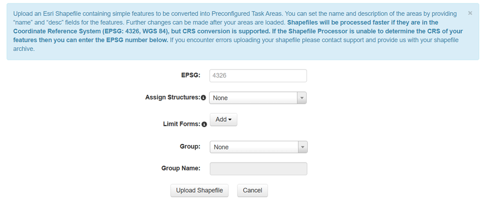
To upload a shapefile
-
In the Preconfigured Tasks module in Administrative Functions, click Add and select Upload Shapefile from the menu.
-
Enter the EPSG coordinate number.
This is a unique identifier for the coordinate system.
-
Assign any structures in the task area when the preconfigured task is created.
-
Add any forms that the task should be limited to. For example, only Residential Damage Assessment forms can be used when working in the task.
-
Assign the task to a preconfigured task Group, or create a new group and give the group a name in the Group Name field below.
-
Click Upload Shapefile and select the file from the file browser.
A new task is created with the boundary defined by the uploaded shapefile.
Related Concepts