These notes describe updates in the Unified Command Platform 10.15 release scheduled for December 18, 2025. More information is available in this help center or by contacting the Juvare Support Center at +1 (877) 771-0911 or support@juvare.com.
New Features
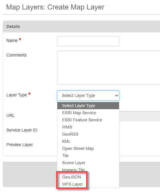
GeoJSON and WFS Support
Expanded mapping capabilities by adding support for GeoJSON and WFS layer types.
Batch PDF REST API
Added support for generating combined PDF documents from multiple board views and records through the Batch PDF API, which includes status tracking and file retrieval. For more info, see Batch PDF.
Maps are not currently supported for Bulk PDF creation.
File Indicators
Added file indicators for multi-file fields in board list views. Users will now see an icon when a field contains one or more files.
![]()
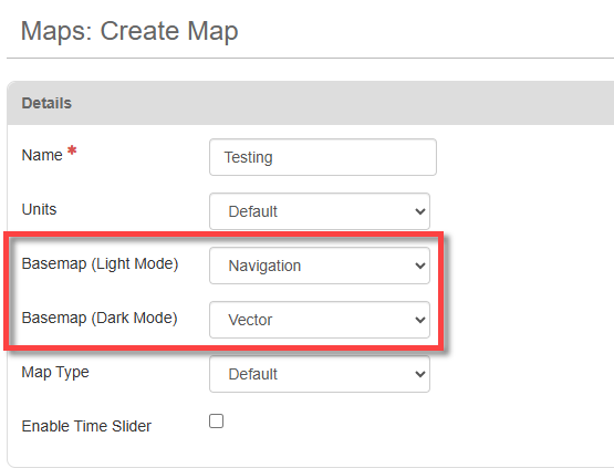
Dark Mode Maps
Introduced support for dark mode basemaps, providing better visibility and an improved user experience in low-light. You can choose different basemaps for light mode and dark mode.
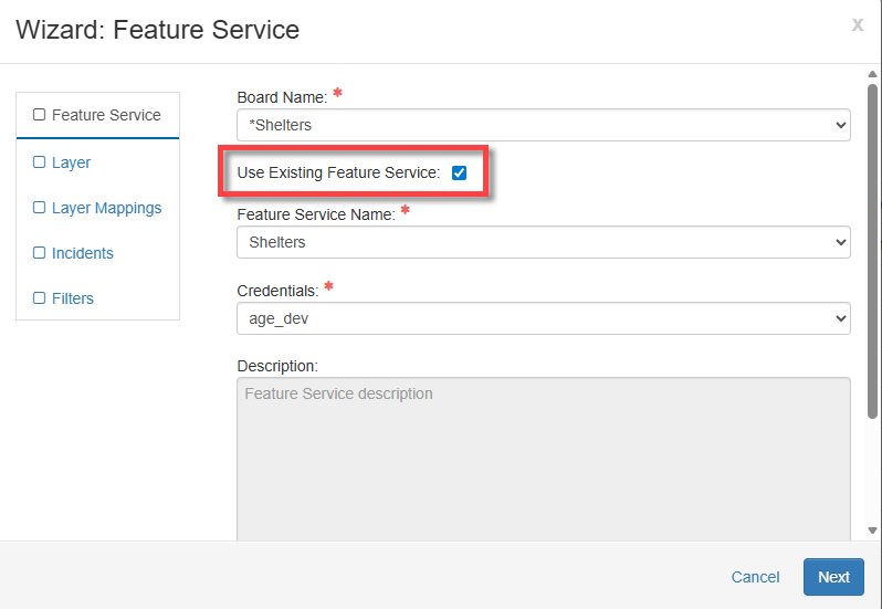
Feature Service Synchronization
Added support for syncing existing ArcGIS Feature Services in the ArcGIS extension. A new checkbox in the Feature Service wizard allows the extension to pull an existing Feature Service instead of creating a new one.
Enhancements
-
In previous versions of WebEOC Nexus, if one board was assigned to multiple groups with the same label, the board displayed multiple times on the Boards page. Now, in this scenario, the board is displayed only once on the Boards page.
-
If a map has multiple layers, in previous versions of WebEOC Nexus, the names of layers on the layers legend came from the WebEOC Nexus layer name, and the layer names were duplicated. Now, the layer names in the layer legend are taken from the ArcGIS layer, rather than the WebEOC layer name. Layers in the legend have meaningful, unique names.
Resolutions
-
Fixed an issue that occasionally caused board refreshes to fail or delay when multiple updates occurred at once on the same board. The refresh process has been optimized to ensure updates appear promptly and consistently across all boards.
-
Fixed an issue importing shapefiles with lines or multilines using the Board Data Manager. The import did not include the map data in the preview, and no map data was imported for the record(s). With the fix, shapefiles are imported correctly in the Board Data Manager.
-
Fixed an issue with 3D maps where 3D topography did not display on the map if the Enable 3D Topography checkbox was selected. With the fix, selecting this checkbox works as expected, and 3D Topography displays on the map.
-
Fixed an issue that caused an error if a board had the <multiplefileinput> tag and no files had been attached. If you attempted to add a data link to this board, an error was displayed. With the fix, adding data links to boards using the <multiplefileinput> tag no longer displays an error if the board has no attachments.
-
Resolved an issue that caused some boards not to function when they were upgraded from WebEOC 9.x to WebEOC Nexus 10.x.
-
Resolved an issue that prevented some boards from refreshing if the board used a view filter with process permissions.
Previous Versions
Release notes for previous versions are available here.